TAS 3252 – Rochon Online Sale
- Estimated Delivery : Up to 4 business days
- Free Shipping & Returns : On all orders over $200
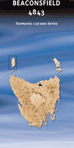
This Topographic Map is produced by the Department of Primary Industries, part of the Tasmanian Government.
These maps are an important resource for Government, industry, and the public. They are used for environmental and emergency management, farm planning and mineral exploration. They are also popular for recreational users such as bushwalkers, mountain bike and horse riders.
The PDF version of this can be printed at home or sent to a professional printer for a 100% scale reproduction.
At this scale, 4cm on this map represents 1km on the ground. A standard map (which is square) covers an area of approximately about 12.5km by 12.5km, with a contour interval of 10m. This map contains natural and constructed features including road and rail infrastructure, vegetation, hydrography, contours, localities and some administrative boundaries.
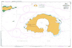
Apprentice Rocks East Telegraph Bay East Telegraph Beach East Telegraph Creek Brandy Creek Cape Rochon Dead Mans Cove Emerald Swamp Ithaca Corner Mermaid Bay Mermaid Rock Middle Hummock North Hummock North West Cape Ranger Retreat Rape Bay Roberts Bay Shark Bay Taniwha Rock Three Gullies Bay Three Hummock Island Three Hummock Island Conservati … Geralds Wood Golden Gully Tomahawk Point Three Hummock Island Conservation Area
| Title | Pdf Download |
|---|