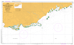
PNG 670 – Gasmata To Fulleborn Including Linden Harbour Fashion
- Estimated Delivery : Up to 4 business days
- Free Shipping & Returns : On all orders over $200
This official Nautical Chart is produced by the Australian Hydrographic Office, and corrected fortnightly to Notice to Marines by Cairns Charts & Maps. This ensures it remains compliance with Safety of Navigation requirements. This marine chart, or sea map , is primarily produced to support the safe navigation of commercial shipping through Australian, Papua New Guinea and Solomon Island waters.
Nautical charts depict the seabed, or bathymetry, using a variety of colours to shade the depth regions. Darker blues indicate shallower water, while light blues and white indicate deeper water. A chart will also show continuous contour lines (at varying intervals depending on the scale of the chart), spot depths across the whole area, as well as different symbols indicating wrecks, shallow rocks and dangers, as well as details on lights, light houses, tides and currents.
For extensive detail on the symbology of nautical charts, the Symbols and Abbreviations used on Admiralty Charts is the definitive reference.
Zitus Zebu West Entrance West Branch Au River Au River West Branch West Branch Walanguo Island Awas Island Wakis Urai Island Umbo Island Umboi Tui Island Atui Island Tolock River Thilenius Harbour Thibenius Harbour Su Island Su Siwat Island Sivot Island Siwot Island Sigilwa Ser Island Serr Island Seilo Island Cape Schirlitz Cape Schirltz Schirlitz Head Schirlitz Point Sand Island Ringring Plantation Ringring Penlolo Paronga Ngati Nangwe Montingteng Island Milewu Island Middle Branch Au River Au River Middle Branch Middle Branch Mia Passage Mia Island Mia Melei Meibun Island Manle Island Manle Malangrut Island Main Entrance Lula River Lulakevi Lue Passage Lue Island Linden Harbour Linden Haven Lindenhafen Plantation Myong Plantation Lilim Island Kolong Island Kiwok Island Kivok Island Kaskas Island Kaskas Kalagen Inibake Island Gurim Island Getmata Gasmata Island Gasmatta Gasmata Fulleborn Plantation Fulleborn Harbour Aleborn Harbour Fullerborn Harbour Fulleborn FUB East Entrance East Branch Au River Au River East Branch East Branch Dililo Island Dawok Island Bumbunu Island Bopinbin River Binnen Island Baronga Island Boronga Island Paronga Island Awrin Island Avring Island Awirin Avihain Avahain Island Au River Au Mission Au Au Bay Atui Anwek River Anuro Island Angles River Anato Amulus River Ami Amgen River Amerer Island Amenpa Ameisen Island Ameison Island Akur Akiwok Akam Aiwit River Awit River Agur Island Agaris River Gasmata Island Airport AYGT GMI
| Title | Paper, Flat Paper, Laminated |
|---|


