Aus ENC PT 907 – Port Pack 907 on Sale
- Estimated Delivery : Up to 4 business days
- Free Shipping & Returns : On all orders over $200
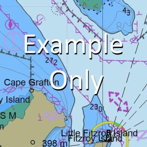
This official collection of Electronic Navigation Charts is produced by the Australian Hydrographic Office. It conforms to S57 IHO Standards and requires an S63 compatible system to operate. ENC are primarily produced to support the safe navigation of commercial shipping, but are equally useful for recreational vessels. ENC can, when used on a Type approved system, replace the need for paper nautical charts.
This AusENC packs contains all the Category 3, 4, 5 and 6 cells which overlap the area depicted in the map. The mapped area is based on the outer coverage of the category 5 and 6 cells within this pack. The category 3 and 4 cells not shown so as to avoid clutter. This pack does not include any category 1 or 2 cells.
For extensive detail on the symbology of nautical charts, the Admiralty Guide to ENC Symbols used in ECDIS is the definitive reference.
ENC Subscriptions
All AusENC packs are supplied as a subscription. This subscription gives you access to the updated information supplied by the Hydrographic Office throughout your subscription period.
Once your subscription is established, the Hydrographic Office will email you your permits (a small text file to load into your system), and then each fortnight will email you to advise if new permits need to be installed. This fortnightly email will also contain a link to the latest updates available.
Nearing the end of your subscription, we will contact you directly to confirm your requirements for a further renewal. You may also receive similar alerts from the Hydrographic Office.
AU130150 AU210150 AU405152 AU5679P0 AU130150 AU130150 AU130150 AU130150 AU130150 AU130150 AU210150 AU405152 AU5679P0 AU405152 AU5679P0 AU405152
Winagut West Point Watpi Point Watering Point Waterhouse Cove Watara Point Watare Point Watara Mission Watara Walwalian Waira Point Waira Virien Vatnabara Mission Vat Island The Wat Utuan Number 2 Utuan Number 1 Utuan Island Urou Uraputput Point Spit Point Urakukur Urakuk Ulu Reef Ulu Mission Ulu Island Mauke Island Pig Island Ukumaina Tonwalik Island Torowalik Ruruan Island Rukukuru Point Ramaitu Point Rakanda Rabumbum Piuka Piratop Palpal Palipal Ololo Nouro North West Passage Narakoi Nambaul Nakukuru Point Nakukura Point Nakukury Point Nakukur Number 2 Nakukur Number 1 Nagaila Nabual Mushroom Rock Mualim Island Mualim Moloi Molot Mioko Reef Mioko Island Meoko Mioke Mioko Harbour Mioko Milamila Mission Milmila Mission Mauke Plantation Maren Manuan Point Manuan Plantation Makada Plantation Makada Island Makadau Mocoda Makada Harbour Mait Unanga Bradley Island Mait Unanga Island Mait Iri Mait Iri Island Mait Channel Hernsheim Passage Levingon Passage East Passage Levinson Passage Laboa Kumlakor Kumaina Kibil Kerawara Island Kerawara Harbour Kerawara Kabinapaoa Point Kabilomu Kabiletad Point Kabiletap Point Kabiatarai Kabapuko Kabakon Reef Kabakon Island Kabakabiui Kababiai Jacquinot Point Invura Mission Inolo Mission Inlimut Foul Bay Duke of York Island Neu Lauenburg Duke of York Group Duke of York Islands Duke of York-Inseln Neu Lauenberg Group Neu-Lauenburg-Inseln Butlivuan Cape Brown Big Pigeon Island Berard Point Balanawang Harbour Port Hunter RAA
| Title | 12Mth Subscription |
|---|
Related products
-
GA 8785 – Wasum Online Sale
$12.50