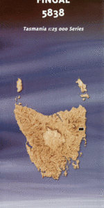
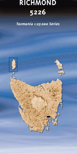
TAS 5226 – Richmond Fashion
- Estimated Delivery : Up to 4 business days
- Free Shipping & Returns : On all orders over $200
This Topographic Map is produced by the Department of Primary Industries, part of the Tasmanian Government.
These maps are an important resource for Government, industry, and the public. They are used for environmental and emergency management, farm planning and mineral exploration. They are also popular for recreational users such as bushwalkers, mountain bike and horse riders.
The PDF version of this can be printed at home or sent to a professional printer for a 100% scale reproduction.
At this scale, 4cm on this map represents 1km on the ground. A standard map (which is square) covers an area of approximately about 12.5km by 12.5km, with a contour interval of 10m. This map contains natural and constructed features including road and rail infrastructure, vegetation, hydrography, contours, localities and some administrative boundaries.
Parkholm Cremorne Hilltop Springfield Cold Blow Lowlands Prospect Strelley Tivoli West Firle Springvale Oak Farm Strathayr Glenayr Talbot Lodge Anglewood Richmond Park Swallowfields Brookbank Ravensbourne Ainsley Park Hastings Ingellara Milton Rae Restdown Blacksmiths Hill Milnathort Gagebrook Old Beach Otago Richmond Downhams Hill Dragon Point Dry Creek Duckhole Rivulet Duke Park Dulcot Eagle Hill Austins Ferry Austins Ferry Bay Barilla Bay Barwicks Rock Basin Hills Beedhams Bay Belbin Rivulet Belbins Saltpans Berriedale Berriedale Bay Berriedale Reserve Billys Island Bilton Bay Birts Hill Blackstone Point Bobs Creek Bourbon Creek Bowen Bridge Bowen Park Brocks Point Butchers Hills Cadbury Cadburys Line Cadburys Reserve Cameron Bay Cassidys Bay Catchpole Gully Claremont Claremont Golf Course Claremont Recreation Ground Clarries Creek Cleburne Point Clemens Hill Clives Hill Connewarre Bay Cove Bridge Cove Creek Cove Hill Craigow Hill Cross Rivulet Derwent Haven Dogshear Point Elliss Point Ferry Point Grasstree Hill Grasstree Hill Rivulet Green Point Green Point Nature Reserve Fryingpan Island Gage Brook Gathering Bush Hill Gunners Quoin Halfmoon Inlet Herdsmans Cove Horatio Point Horse Hill Horton Hill Huon Gully Jacques Creek James Austin Park Karls Hill Knights Point Lands End Lennox Park Lowestoft Bay Madmans Hill Malcolms Creek Marengo Creek McCarthys Point Meehan Range Meehan Range Nature Recreation … Meehan Range State Recreation Area Moores Creek Morgans Point Mount Direction Mount Direction Conservation Area Mount Lord Mount Pleasant Nichols Hill Otago Bay Pages Creek Park Hill Pigeon Hole Rivulet Pontos Hills Quoin Gully Quoin Ridge Railway Point Restdown Point Richmond Bridge Richmond Gaol Historic Site Richmond Golf Course Risdon Brook Risdon Brook Reservoir Risdon Cove Risdon Vale Risdon Vale Creek Roseneath Park Roseneath Rivulet Rusts Bay Saggy Flats Saltbush Point Samphire Island School Hill Shark Point Shed Hill Shelstone Saddle Shones Corner Shoobridge Park Southern Regional Water Suppl … Split Rock Saddle Stinking Point Stony Creek Strelley Hill Tent Hill The Ovens Thistly Gully Weston Park Whitestone Point Wilkinsons Point Windermere Windermere Bay Windermere Beach Woodville Bay Bowen Park Lagoon Briggs Creek Churinga House Cross Rivulet Bridge Duckhole Creek Bridge Duckhole Rivulet Bridge Lagoon Bay Pages Creek Bridge Pitt Water Nature Reserve Prickly Hollow Bridge Seaton Stony Creek Bridge The Dry Creek River Jordan Jordon River Sheonk Hill Butchers Hill Grass Tree Hill Duck Hole Creek Coal River Abbotsfield Rivulet Meehan Range Nature Recreation Area Faulkners Rivulet Risdon Crosses Rivulet
| Title | Pdf Download |
|---|